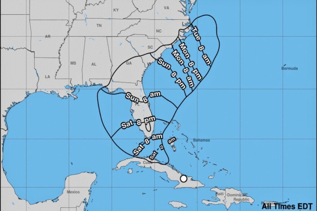
Potential Tropical Cyclone Four will hit Florida starting Saturday evening and throughout Sunday, according to the National Weather Service (NWS) forecast.
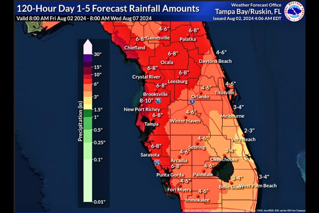
The NWS advisory projects wind speeds of 39-plus miles per hour with rainfall of four to eight inches in North Central Florida.
“It is important to remember that Alachua County is already between 4 to 7 inches above our normal 30-day rainfall totals, so our area is already saturated,” a Friday press release from Alachua County said. “It may not take as much rain to cause some areas to flood. This storm is not expected to start impacting Alachua County in a significant way until late Saturday, but more likely into Sunday, so residents and visitors should be taking steps early to secure property in areas that are at high risk for flooding. Homes and other properties in flood-prone areas should be assessed to determine if there are ways to protect the property from flooding danger.”
On Thursday, Gov. Ron DeSantis issued an emergency preparedness declaration for Florida for then tropical disturbance Invest 97L.

The Florida Fish and Wildlife Conservation Commission (FWC) sent a release out on Friday afternoon urging vessel owners to secure their boats and plan for severe weather.
The FWC offered the following tips:
Move your vessel if you can and protect it if you can’t
- If your boat can be trailered, haul it out of the water and move it to a safe location as far from tidal waters as possible. This includes kayaks and other recreational watercraft.
- If your vessel must stay in a marina berth, double all lines and rig cross spring lines fore and aft, and attach lines high on pilings to allow for tidal rise or surge.
- If your vessel is at anchor, move to the most protected area possible and set out multiple anchors with at least a 10:1 scope, remove canvas coverings if possible and remove or secure any sails.
- If your vessel will remain on a mooring, make sure the mooring is designed to withstand the load your vessel will place on it. Inspect chains and swivels connecting to the mooring buoy and double up on the pendant.
- Remember to remove Electronic Position-Indicating Radio Beacons (commonly known as EPIRBs), life rings, lifejackets and loose items from the boat and store them in a safe, indoor location.
- Use the Florida Boat Ramp Finder to find a ramp near you.
Cover all lines to prevent chafing
- Wrap all lines where they feed through chocks with tape, rags, rubber hoses or leather. Install fenders, fender boards or tires to protect the boat from rubbing against the pier, pilings or other boats.
Charge batteries and make sure they can run automatic bilge pumps throughout the storm.
- Consider adding backup batteries and shut off all other devices that consume electricity.
Do not stay onboard and do not venture out into rough conditions
- During a hurricane, winds can exceed 100 mph and tornadoes are often associated with these storms. If you’re on board during a bad storm, you risk your life and the lives of potential responders.
- Learn what Florida law says about mandatory marina evacuations. Chapter 327.59, F.S., Marina Evacuations.
Monitor weather broadcasts frequently and comply with evacuation orders when issued
- Storm tracking through the National Hurricane Center.
- Follow FloridaDisaster.org.
Suggested Articles
No related articles found.


