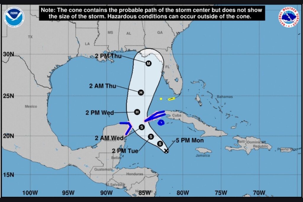
Potential Tropical Cyclone 9 is projected to develop into a Category 3 hurricane by Wednesday evening, according to a National Hurricane Center (NHC) report.
The NHC released an update at 5:30 p.m. on Monday saying the current Potential Tropical Cyclone 9 will turn into a tropical storm tonight with winds near 35 miles per hour. The storm will intensify Tuesday through Thursday. Heavy rainfall and isolated tornadoes are forecasted, according to the National Weather Service (NWS) as the potential Category 3 hurricane, with winds greater than 110 miles per hour, will hit landfall in the Big Bend area of Florida on Thursday.
Gov. Ron DeSantis declared a state of emergency on Monday afternoon for 41 of Florida’s 67 counties. The state of emergency affects Alachua, Bay, Bradford, Calhoun, Charlotte, Citrus, Collier, Columbia, Dixie, Escambia, Franklin, Gadsden, Gilchrist, Gulf, Hamilton, Hernando, Hillsborough, Holmes, Jackson, Jefferson, Lafayette, Lee, Leon, Levy, Liberty, Madison, Manatee, Marion, Monroe, Okaloosa, Pasco, Pinellas, Santa Rosa, Sarasota, Sumter, Suwannee, Taylor, Union, Wakulla, Walton, and Washington counties.
The Alachua County Commission has converted its 11:30 a.m. regular meeting on Tuesday into an emergency meeting to consider a state of emergency as the storm approaches.
The NHC will issue an update on Tuesday morning for likely storm surge and hurricane watch.
It has been a relatively quiet hurricane season after National Oceanic and Atmospheric Administration experts forecasted an above-normal year for Atlantic storms in May. Hurricane Debby made landfall in North Florida in August and caused over $93 million in agricultural losses, according to a UF/IFAS report released on Thursday.
Click here to find out how to prepare for the upcoming storm.
Suggested Articles
No related articles found.


